Ahmad Kamal Nasir, PhD
Director engineering laboratory
Assistant professor of electrical engineering, school of science and engineering
lahore university of management sciences, pakistan
|
|
In 2015, I along with Prof. Dr. Mian Muhammad Awais have established a Precision Agriculture and Forestry Research Cluster within School of Science and Egnineering of Lahore University of Management Sciences. The cluster has Unmanned Airborne Remote Sensing Facility in order to fill a gap between satellite based and ground based geo-sensing systems. The objective of this facility is twofold:
In 2018, along with three other colleagues from LUMS, we got a funding of US$ one millions from HEC to establish first National Agriculture Robotics Lab at LUMS, Pakistan. Currently, Six projects in three areas, water efficency, reliable crop monitoring and enviorment sustainability are underway at the lab. Following are some of my research projects: |
| Funded Project |
|
PRECISION AGRICULTURE: TALKING FIELDS – MULTI MODAL SPATIAL TEMPORAL CROP CLASSIFICATION AND AREA ESTIMATION SYSTEM, 2019-20 DAAD Research Cooperation Grant between LUMS - Uni Siegen, (PI: Prof. Dr. –Ing. Hubert Roth, Dr. –Ing. Ahmad Kamal Nasir, Co-PI: Dr. Aamir Shahzad, Dr. Maria Anjum); 80,000 EUR |
|
NATIONAL AGRICULTURE ROBOTICS LAB, 2018 Higher Education Comission Pakistan (HEC), (PI: Dr. Abubakr Muhammad, Co-PI: Prof. Dr. Mian Muhammad Awais, Dr. –Ing. Ahmad Kamal Nasir, Dr. Murtaza Taj); 1,000,000 US$ |
|
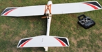
DEVELOPMENT OF A LONG ENDURANCE HYBRID UAV FOR AGRICULTURAL AND FORESTRY APPLICATIONS, 2017 LUMS Faculty Initiative Fund (FIF), (PI: Dr. –Ing. Ahmad Kamal Nasir, Co-PI: Prof. Dr. Mian Muhammad Awais), 10000 US$ |
|
ESTIMATING WATER STRESS INDEX FOR PRECISION AGRICULTURE APPLICATIONS USING A THERMAL CAMERA, 2016 LUMS Center for Water Informatics and Technology (WIT), (PI: Dr. –Ing. Ahmad Kamal Nasir), 5000 US$ |
|
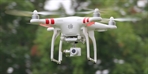
DEVELOPMENT OF A LOW COST HIGH RESOLUTION AERIAL MAPPING SYSTEM FOR CARBON SEQUESTRATION: POTENTIAL OF TREES IN AND AROUND LAHORE CITY, 2016, LUMS Faculty Initiative Fund (FIF), (PI: Dr. –Ing. Ahmad Kamal Nasir, Co-PI: Prof. Dr. Mian Muhammad Awais), 10000 US$: The proposed research project will explore the possibilities of development of low-cost robotic systems for aerial mapping of areas using Unmanned Aerial Vehicles (UAV(s)) in order to estimate carbon sink and/or stock and vegetation. The use of satellite images with field survey could be a suitable approach for assessing forest degradation and deforestation but are expensive compared to the aerial mapping using a low-cost quadcopter. |
|
PRECISION FORESTRY: GREENDRONE -DEFORESTATION AND FOREST DEGRADATION ESTIMATION USING AN UNMANNED AERIAL VEHICLE, 2016-17, DAAD Research Cooperation Grant between LUMS - Uni Siegen, (PI: Dr. –Ing. Ahmad Kamal Nasir, Prof. Dr. -Ing. Hubert Roth, Co-PI: Prof. Dr. Mian Muhammad Awais), 80000 EUR: The proposed low-cost system can estimate carbon sink/stock and shall identify forest degradation and deforestation for underdeveloped countries such as Pakistan. The system can be used as a monitoring, reporting and verification tool for Reducing carbon Emission of Deforestation and forest Degradation (REDD). |
|
AUTONOMOUS CONTROL OF UNMANNED GROUND VEHICLE (MARWA), 2014-15, National Grassroots ICT Research Initiative of Pakistan, (Supervisor: Dr. –Ing. Ahmad Kamal Nasir), 1000 US$: MARWA is a four wheeled robot that was initially designed to provide a robotic solution to the problem of landmine detection and therefore help prevent casualties. Our project is a continuation of the work that was done at the CYPHYNETS LAB at LUMS for the NI Landmine Detection Competitions held in Lebanon in 2011.The project is an integrated setup which can be broken down into three separate areas of work. The first module focuses on learning about the existing mechanical structure of MARWA, currently only steered by the front wheels, and implementing mechanical fixtures that will allow the robot to become a double parallel steered system for navigation. The second module aims at designing a solution for power distribution requirements of the robot. This will involve catering to the varying power level requirements of the robot electronics including the motors, encoders and any sensors that are later made a part of this project. The third module is the main module of the project and requires the implementation of odometry control for the robot. This will be required in order to make the robot capable of following any trajectory that it is given with greatest accuracy. EMBEDDED 6 DOF VISUAL-INERTIAL ODOMETRY FOR AERIAL AND GROUND ROBOTS, 2014-15, Higher Education Commission of Pakistan, (PI: Dr. –Ing. Ahmad Kamal Nasir, Co-PI: Prof. Dr. Abubakr Muhammad), 5000 US$: This research work will create an inexpensive solution based on mobile devices which can be used as standalone navigation device by aerial and ground mobile robots. Our motivation is to use a cheap android based tablet, which now a days has enough computational power, to perform real time navigation for aerial and ground mobile robots. The proposed solution helps to reduce the unbounded IMU pose drift errors, therefore, it makes possible to use the mobile platform as standalone device for mobile robot applications. |
| Graduate Projects |
|
MS(CS) Thesis, SLAM for Precision Forestry ,Omair Hassan, LUMS Fall/Spring 2015/16: The main focus of this thesis is to study existing single camera mapping techniques and methodologies. Furthermore, to implement a forests aerial mapping method using single camera. The outcome of this project can be directly applied to create a 2D/3D aerial map and for near real-time surveillance of the forest area. This project work is divided in two phases. In the first phase, different Visual SLAM algorithms related to our application will be studied and evaluated.In the second phase a suitable algorithm will be implemented for aerial mapping of forest area using a quad-rotor. We will also look into different problems related to visual images i.e image classification, segmentation etc. We will study and implement different algorithms for vegetation classification e.g tree counting. So that we can better classify images at run time, which will eventually help in a better 3D map creation MS(EE) Thesis, Inertial Visual Sensor Data Fusion, Qazi Hamza Jan, LUMS Fall/Spring 2014/15: This thesis spotlights on navigation of autonomous robots. Avoiding obstacles is the fundamental challenge in navigation of autonomous robots. In this thesis, navigation is performed with the assistance of two sensors which are Inertial Measurement Unit (IMU) and camera. Most of the robots are equipped with these two sensors nowadays. These sensors when utilized independently do not give exceptionally precise results. Navigation from IMU has a great deal of drift because small errors in measurement are accumulated from point to point. Correspondingly, visual odometry becomes ine_ective in environments where feature detection is not accurate like night time. To overcome the limitations of these indivisual sensors, we perform sensor fusion to obtain a precise and robust estimate for navigation. |
| Under-graduate Projects |
|
BS(EE) SProj, Precision Forestry: Development of an autonomous forest mapping system using a quad-copter, LUMS, Fall/Spring 2015-16: The main focus of this senior project is development of a autonomous aerial mapping system for forestry applications.The developed system can be used by the forestry people for survey and monitoring applications. This project work is divided in two phases. In the first phase a literature survey regarding our application and existing mapping techniques will be studied. During the second phase our proposed technique will be implemented and evaluated. BS(EE) SProj, Autonomous Lawn Mower LUMS, Fall/Spring 2014-15: The aim of this project is to build upon the work done on the autonomous robot by the previous year's SProj group and work towards building a user-friendly, feasible and safe autonomous lawn mower that requires minimal user intervention and is reliable enough to be used in households and parks. The user would only be required to charge the batteries and place the robot in the lawn and switch it on. The lawn mower will handle the rest. Once the design is finalized, it could be introduced in the local market for household and commercial use. We will be using different techniques to fulfill our aim. Autonomy would be achieved by incorporating and integrating the following on the robot: " Obstacle avoidance" SLAM(Simultaneous Localization And Mapping) " Terrain Classification". A user-friendly interface on top of the lawn mower would be built allowing the user to easily monitor the robot's status including the batteries. Safety mechanisms would be incorporated including emergency kill-switch, emergency brakes, on-state lights and buzzer. BS(EE) SProj, Autonomous Control of UGV Marwa LUMS, Fall/Spring 2014-15: MARWA was designed to provide an economical robotic solution to facilitate the process of mine detection. The mechanical design of the robot is therefore, made of an aluminium structure to provide support to the mechanical arm that carries the metal detector used to detect mines. The weight and size of the robot result in limitations over the drive that can be used to animate the robot. Furthermore, the robot is a four wheeled body that can be driven by a tank like drive, a differential drive or a car like steering mechanism. The tank drive requires both wheels to move with the same speed. If this is not the case the robot will not be able to move straight as the slower wheel slips something that can prove to be problematic during the demining process. The differential drive though increasingly being considered for Electric Vehicle (EV) are difficult to model as they are modeled by curvilinear motion where the wheels roll and slide at the same time. The car like steering drive allows us to overcome these problem as the drive is based on the principles of four wheel drive. Therefore, due to the mechanical structure of MARWA that was built to serve the original purpose of mine detection we will employ the four wheel drive for optimum and sophisticated control of the robot during the demining process. BS(EE) SProj, Robotic Calligraphy LUMS, Fall/Spring 2014-15: Robotic Calligraphy is a relatively new area of research and poses a challenge to preciseposition control and precise force-control. It has numerous applications, from simple production of calligraphic works on paper or ornaments, to writing calligraphy on large canvases that may include dome shaped structures that are difficult to reach by the human calligrapher. Calligraphy robots are also very similar to the manipulators required to perform surgery as the task of incisions using the scalpel requires dexterity through precise position control and smooth, directional and continuous motion. Thus the aim of this project will be to create the basic structure for a robotic arm that can reproduce Urdu calligraphy done by a human. The goal of the project is to design and simulate a robotic arm that can take an input from a touch screen and replicate the calligraphic motion of the letters entered by recording the trajectory of the stroke and adjusting the angle of the end effectors. The system should be able to write smooth curves that vary in width without tearing the paper or damaging the nib of the pen. |
|
|